

")
October 2017
Dr Piet Nell, ARC-Soil, Climate and Water
At the very first South African Irrigation Congress held in 1909, much concern was expressed at the extent of salt- affected soils and the sediment content of water supplies (Kanthach, 1909). At the National Irrigation Symposium 82 years later, Scotney and Van der Merwe (1991) had the same concerns and said that the long-term viability of soil and water resources is in jeopardy. Major threats to these resources result from, among others, salinity, sodicity and waterlogging.
A review of about 3 000 soil irrigation reports at the ARC-Soil, Climate and Water, revealed that soils free of limitations for sustainable irrigation are limited in extent in South Africa. However, it appears that waterlogging, salinity and sodicity affects only 10% to 18% of the area under regular irrigation in South Africa.
This is much lower than experienced in many countries, because of the strict emphasis placed on the potential for waterlogging, salinity and sodicity and its prevention in the selection criteria for irrigated soils in South Africa in the past. Another advantage is the generally good water quality that has historically been available for irrigation in South Africa.
Currently the salinity and sodicity of South African waters are on the increase due to mining, urban, industrial and agricultural developments and the re-use of water resources. Irrigated agriculture is not only at the receiving end of water quality deterioration, but also a contributor to water quality deterioration experienced in many rivers. The use of this water poses a future threat for soils on South African irrigation schemes where leaching is limited.
It is evident from information available that the degree of degradation varies considerably between irrigation schemes and also over time within the same irrigation scheme in South Africa. An increase in salinity and sodicity normally coincide with hydrologically dry years with below-average runoff and an increase in waterlogging during hydrologically wet years.
Satellite images to quantify and identify salt-affected soils and waterlogging
National monitoring of waterlogging and salt accumulation are a high priority, but currently no verified methodology is available to undertake this task. A recently completed Water Research Commission project by researchers from the ARC-soil, Climate and Water and Stellenbosch University sought to determine the potential of various data sources and techniques for monitoring waterlogging and salt accumulation and to quantify the current level of waterlogging and salt accumulation and monitor changes over time at the appropriate scale on irrigation schemes in South Africa (Nell et al., 2015).
Remote sensing is the practice of deriving information about the earth’s land and water surfaces using images acquired from an overhead perspective, by employing electromagnetic radiation in one or more regions of the electromagnetic spectrum, reflected or emitted from the earth’s surface.
The challenge with using remote sensing for identifying and delineating waterlogged and salt-affected areas is that they are local manifestations and can only be differentiated from unaffected areas by taking its context (surrounding area) into consideration. For instance, an affected area within a wheat field will have very different spectral properties to an affected area in a vineyard, while the latter will have a very different spectral response compared to an affected area within a bare/fallow field.
The occurrence of salt accumulation and waterlogging in generally mall patches in South African irrigation schemes poses additional challenges.
Three approaches to mapping waterlogged and salt-affected areas were identified as potential solutions. The first is a modelling approach whereby hydrological, terrain and soil data is used to determine where waterlogging or salt accumulation is likely to occur.
Another approach is to differentiate affected and unaffected soils by making use of remotely-sensed imagery (hyperspectral or multispectral) to analyse their spectral properties. This direct remote sensing method is consequently applied to exposed (bare) soil.
The third approach, referred to as the indirect remote sensing approach, examines vegetation response (e.g. loss of biomass) to saline or waterlogged conditions.
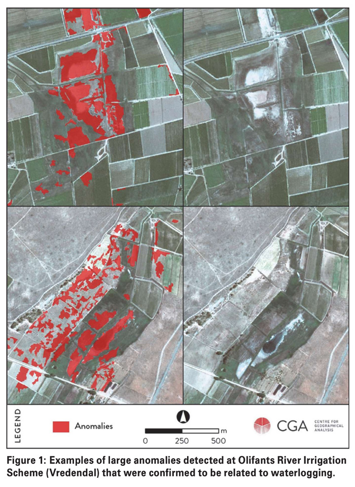
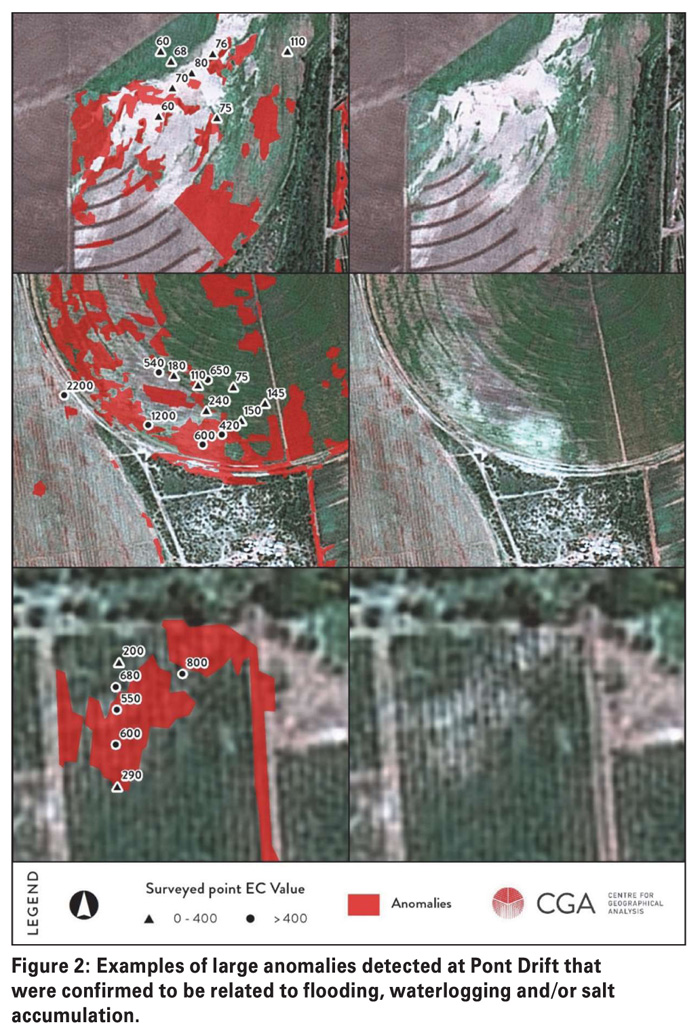
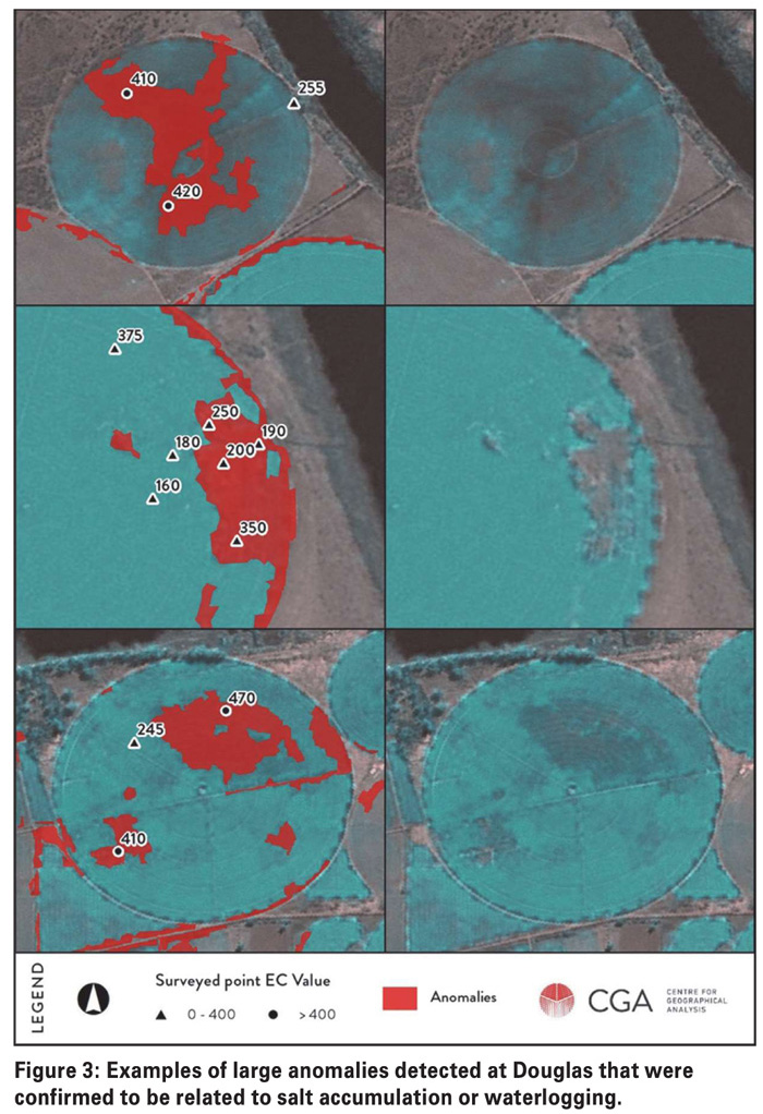
It became clear that image texture (heterogeneity) is an important feature for identifying areas that are likely to be salt-affected or waterlogged. The newly-developed within-field anomaly detection (WFAD) method is based on the principle that heterogeneous areas are in many cases indicative of waterlogging or salt accumulation.
Affected areas often stand out as being spectrally different compared to the rest of a field, either because of a reduction in biomass due to saline or saturated conditions (in cultivated fields) or due to specific species of vegetation occurring in fallow fields. Although such ‘anomalies’ can be easily identified using visual interpretation of imagery, they are not easily extracted from remotely-sensed data.
Traditional remote sensing techniques involve classifying individual pixels (cells) without taking topology (relationships between spatial entities) into consideration. The results showed that, compared to the other methods evaluated, within-field anomaly detection produced the most promising results for monitoring and quantification purposes.
The technique not only produced accurate results, but is also cost-effective as it can be applied on both vegetated and non-vegetated fields, requires no empirical data, makes use of freely available imagery (SPOT-5 and 6); and has the potential to be fully automated.
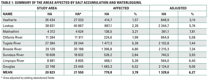
Quantification of salinity, sodicity and waterlogging in South Africa
From previous studies it appears that severe waterlogging, salinity and sodicity affects 8% to 18% of the area under regular irrigation in South Africa (Backeberg et al., 1996). Ghassemi et al. (1995) stated that a survey of five major irrigation schemes in South Africa indicated that, on average, 28% of irrigated land shows signs of either waterlogging or harmful high salt contents or both.
Salt-affected and waterlogged figures of 18% to 28% for South Africa seem unrealistic if compared to the current study of 6,27% (Table 1). If the figure of 6,27% of areas affected is applied to the 1,5 million hectares under irrigation in South Africa, the area that is salt-affected and waterlogged on South African irrigation schemes is 94 050 ha.
References
Backeberg, GR, Bembridge, TJ, Bennie, ATP, Groenwald, JA, Hammes, PS, Pullen, RA and Thompson, H. 1996. Policy proposal for irrigated agriculture in South Africa. WRC Report No. KV96/96, Water Research Commission: Pretoria.
Ghassemi, F, Jakeman, AJ and Nix, HA. 1995. Salinisation of land and water resources: Human causes, extent, management and case studies. University of New South Wales Press Ltd: Sydney.
Kanthaach, FE. 1909. Irrigation development in the Cape Colony: Past, present and future. Proc.1st S. Afr. Irrig. Cong., 24 – 35. Cape Times Ltd: Cape Town.
Nell, JP, Van Niekerk, A, Mulller, SJ, Vermeulen, D, Pauw, T, Stephenson, G and Kemp, J. 2015. Methodology for monitoring waterlogging and salt accumulation on selected irrigation schemes in South Africa. Water research Commission Report: TT 648/15, Pretoria.
Scotney, DM and Van der Merwe, AJ. 1991. Irrigation: Long-term viability of soil and water resources in South Africa. Proceedings of the Southern African Irrigation Symposium. 4 – 6 June 1991, Elangeni Hotel: Durban.
Publication: October 2017
Section: Focus on


