


ARC-Institute for Agricultural Engineering
The purpose of agricultural drainage is to remove excess water from the soil in order to enhance crop production. In some soils, the natural drainage processes are sufficient for the growth and production of agricultural crops, but in many other soils, artificial drainage is needed for efficient agricultural production.
Drainage is regulated by the Conservation of Agricultural Resources Act (CARA) No. 43 of 1983 and it states: ‘To provide for control over the utilisation of the natural agricultural resources of the Republic in order to promote the conservation of the soil, the water sources and the vegetation and the combating of weeds and invader plants; and for matters connected therewith.’ Article 6 of CARA (Control measures) states inter alia:
- In order to achieve the objects of this Act the Minister may prescribe control measures which shall be complied with by land users to whom they apply.
- Such control measures may relate to the:
-
- cultivation of virgin soil;
- utilisation and protection of land which is cultivated;
- irrigation of land;
- prevention or control of waterlogging or salination of land;
- utilisation and protection of vleis, marshes, water sponges, water courses and water sources;
- regulating of the flow pattern of runoff water;
- utilisation and protection of the vegetation;
- grazing capacity of veld, expressed as an area of veld per large stock unit; and
- maximum number and kind of animals which may be kept on veld.
It is important to distinguish between surface and subsurface drainage, since the causes are usually very different and require different approaches to solve them.
This article will concentrate on surface drainage and the principles that apply to it.
 Surface drainage
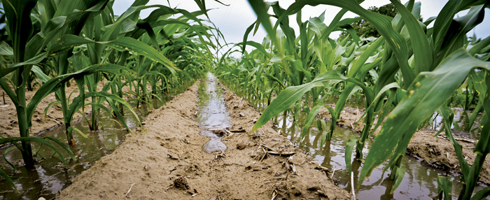
Surface drainage is the removal of water that collects on the land surface. Many fields have low spots or depressions where water ponds. Surface drainage applies primarily on flat land where in combination with factors such as slow infiltration, low permeability, restricting layers in the soil profile or shallow soil covering rock or deep clays, it prevents the ready percolation of rainfall, runoff, seepage from uplands, or overflow from streams through the soil to deep stratum.
A surface drainage system needs to be designed to remove excess water at a rate which will prevent long periods of standing water so that crops will have optimum conditions for growth. It should minimise the risk of flooding without excessive soil erosion. Surface drainage techniques such as land levelling, constructing surface inlets to subsurface drains, and the construction of shallow ditches or waterways, can allow the water to leave the field rather than causing prolonged wet areas. The design capacity of drainage systems therefore depends on several interrelated factors, including rainfall patterns, soil characteristics and the type of crop grown.
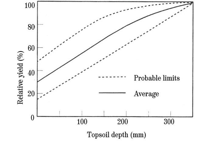
The effect of soil loss on crop yield is illustrated in Graph 1. In order to sustain crop yields from cultivated lands, it is necessary to limit soil erosion to sustainable rates as the consequence of not doing so will result in reduced crop yields. In most situations the erosion of soil by runoff exceeds soil lost by wind erosion. The objectives of surface runoff management are to:
-
-
- reduce soil erosion to sustainable amounts;
- improve the quality of runoff water from a field; and
- utilise rainfall effectively in order to provide for maximum retention of moisture for crop use.
-
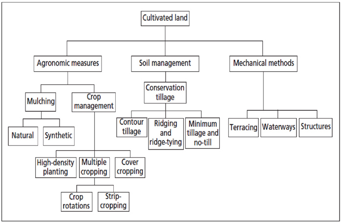
As shown in Figure 1, soil management, agronomic and mechanical approaches can be used to manage runoff from cultivated lands. It is recommended that all the approaches are used concurrently to limit runoff and soil erosion.
Principles that apply with runoff control in surface drainage
Proper runoff control planning has many benefits, including the following:
-
-
- Less soil erosion, which also means fewer nutrient losses.
- The delay in runoff means that more water enters the soil.
- If the soil profile is saturated, the contours will safely drain away the excess water.
- Flood water can be handled better and cause less damage to the lands.
- As a result, crop yields increase.
- The watercourses can be cut and baled and thus become a good source of winter feed.
-
Planning and fieldwork investigations
Runoff control planning (RCP) must be applied mainly to areas which are cultivated intensively. It involves the disposal of runoff water from where the runoff starts forming to where it discharges safely into a river or higher order watercourse, without causing erosion on its way. The physiography of an area plays the principal part in this planning. Although secondary, the utilisation of the soil also plays a part. RCP can encompass a farm, part of a farm, or an area comprising of a number of farms – provided the relevant pieces of land are bounded by watershed boundaries.
RCP involves the drawing up of a plan for the safe discharge of surplus (surface runoff) water from an area. This plan must be in accordance with the natural drainage pattern and could include artificial measures which might have to be used to protect the soil.
It embraces the planning of all areas, farms or localities where runoff water can cause erosion.
The scope of RCP includes the following:
-
-
- The identification of all natural watercourses and siting of suitable artificial waterways.
- Identifying erosion risks, the choice of conservation systems and the norms according to which these should be designed.
- The identification of man-made structures and the preservation/improvement of these.
-
Application
Applications of RCP are necessary in the following instances:
-
-
- In the event that runoff water in concentrated form causes erosion and/or waterlogging.
- Where runoff water causes boundary water disputes between producers on intensively cultivated land.
- In cases where runoff water (flood water) from roads, railways, townships etc. has to be matched with the natural drainage pattern.
- Where runoff water causes waterlogging or brackish soil.
-
Framework for RCP
The accepted principle is that runoff from higher lying land should not reach lower lying land (for instance in the case of a farm boundary) along unnatural drainage lines or in more concentrated form.
Act No. 43 of 1983 requires that every landowner has to ensure that soil on his land is not subject to unsustainable erosion and that neglect or indifference does not lead to the withdrawal of land from production.
Important rules for RCP
The following rules are important for RCP:
-
-
- Natural watersheds must be respected and only under very special circumstances may runoff water be transferred between watersheds.
- The natural watercourse areas (stream lines) must also be respected. Where watercourses had been ploughed, they must be reconstituted by constructing a grassed (or other type of) waterway on the streamline. Exceptions may only be made in areas with large natural stream densities and where all natural watercourses are not necessarily turned into waterways.
- An investigation into water runoff planning usually starts in the upper reaches of a catchment area and then continues downhill or downstream to where a higher order drainage component such as a marsh, tributary or river is reached.
- A runoff control plan is usually executed by starting at the downstream point of a watercourse, working upstream from there. Under certain circumstances it is expedient to execute a project over its total length simultaneously.
-
Contour lines
Contour lines indicate points of the same elevation on a map. In other words, a contour line is a level line. Runoff water will – because of gravitation – always choose the direction of the steepest slope. A drop of water starting to move, will move perpendicularly to the contour lines. This action will continue as the water volume grows through stages of dispersed surface runoff and concentrated surface stream flow up to the stage of canal flow – the natural flood conditions found in a tributary or river.
Guidelines and technical specifications for surface drainage
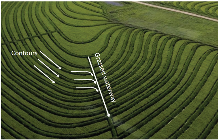
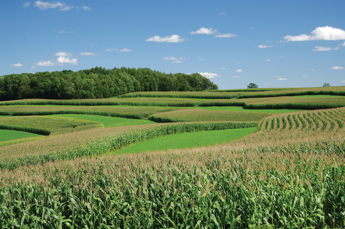
When soils on sloping terrain are cultivated and subjected to erosive rainfall, it is usually necessary to supplement the agronomic and soil management measures with other practices in order to delay the runoff and reduce the transported sediments. These practices, generally referred to as mechanical measures, consist of waterways and contour banks or terraces that drain into stable waterways, as shown in Figure 2. A contour bank can potentially reduce soil loss per unit surface by 50%. There are also reductions in soil losses as a result of the tillage which takes place next to the contour bank.
The aim of contour banks is to limit soil erosion to an acceptable rate. This is achieved by limiting the length of flow down a slope, controlling runoff and directing the runoff into a channel, referred to as a waterway. Thus, the most important aspect of contour bank systems is the spacing of the contour banks. If the ‘correct’ spacing or slope length is known, then the design of a contour bank is a simple operation. Unfortunately, the spacing of contour banks cannot be precisely determined and it is frequently not possible to determine a method for spacing that will be applicable in all situations. In addition to limiting the slope length of runoff, contour banks also have to safely discharge the runoff – they must have adequate discharge capacity. The design of contours to adequately discharge the required capacity and the spacing between contours to limit soil erosion are of great importance. The following should be considered in this regard:
-
-
- The estimation of design floods for the design of hydraulic structures and thus to quantify and limit the risk of failure of the structures.
- A contour bank design that includes both the design of the vertical and horizontal spacing between contour banks and the design of the contour to safely discharge the runoff.
-
Spacing
The spacing of contour banks is fairly specialised and can be determined with several methods. The Universal Soil Loss Equation (USLE) is the preferred approach and incorporates soils, slopes, rainfall and cropping systems in the design of contour spacing.
The following criteria should be adhered to in all contour bank designs:
-
-
- Contour bank spacing must not be narrower than 20 m and not wider than 60 m.
- On the steeper slopes, contour banks must be specifically designed and, where necessary, supportive biological measures must be included in the design specifications to keep soil losses within the permissible range.
- A cross-sectional shape should be selected to fit the slope, crop and machinery used and the embankment should have a minimum width of 0,9 m.
- The spacing of contour banks should be integer multiples of the effective implement working width. For example, if a 4-row machine with rows of 900 mm wide is used, then the spacing should be multiples of 3,6 m.
- Contour bank spacing can be increased by up to 10% to improve alignment, avoid obstacles, accommodate machinery or to reach a satisfactory outlet.
- It is recommended that contour banks have long, smooth, gentle curves with radii > 30 m.
-
![]() Conclusion
Conclusion
The purpose of agricultural drainage is to remove excess water from the soil in order to enhance crop production. One of the techniques is to do proper runoff control planning that includes designed waterways and contours. Contouring is a practice of tilling sloped land along lines of consistent elevation in order to conserve rainwater and to reduce soil losses from surface erosion. These objectives are achieved by means of furrows, crop rows and wheel tracks across slopes – all of which act as reservoirs to catch and retain rainwater, thus permitting increased infiltration and more uniform distribution of the water.


